


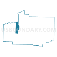
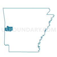
Oliver Voting District, Scott County, Arkansas
About
Outline

Summary
| Unique Area Identifier | 528085 |
| Name | Oliver Voting District |
| County | Scott County |
| State | Arkansas |
| Area (square miles) | 22.07 |
| Land Area (square miles) | 21.31 |
| Water Area (square miles) | 0.77 |
| % of Land Area | 96.53 |
| % of Water Area | 3.47 |
| Latitude of the Internal Point | 34.90277570 |
| Longtitude of the Internal Point | -94.25517710 |
Maps

Graphs
Select a template below for downloading or customizing gragh for Oliver Voting District, Scott County, Arkansas


Neighbors
Neighoring Voting District (by Name) Neighboring Voting District on the Map
- Voting District 9-3-K, Sebastian County, AR
- Blansett Voting District, Scott County, AR
- Brawley Voting District, Scott County, AR
- Cauthron Voting District, Scott County, AR
- Denton Voting District, Scott County, AR
- Hon Voting District, Scott County, AR
Top 10 Neighboring County Subdivision (by Population) Neighboring County Subdivision on the Map
- Sugarloaf township, Sebastian County, AR (1,657)
- Hon township, Scott County, AR (383)
- Denton township, Scott County, AR (373)
- Cauthron township, Scott County, AR (160)
- Blansett township, Scott County, AR (158)
- Brawley township, Scott County, AR (106)
- Oliver township, Scott County, AR (59)